

Tim Ridgway reports on Brighton and Hove’s hidden waterways and the flooding threat they pose.
When Steve and Michelle Langley bought a home in High Street, Portslade, more than a decade ago, they had no idea of the potential trouble lurking below.
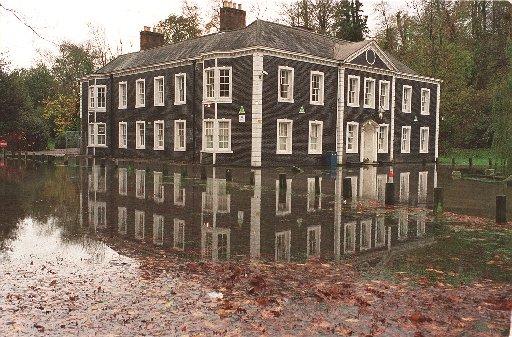
But last month the couple had to spring into action when water began flooding into their basement.
For two weeks they had to pump up to 900 gallons of water an hour out of the underground den into a sewer.
The couple were initially bemused as to why their home, which is partly up an incline and more than a mile inland, was flooding.
The reason, they have since learned, is rising groundwater.
It is a strange phenomenon and one that not many people in Sussex are aware of.
But, in the winter and spring months after a period of prolonged rainfall, water levels in underground streams travelling down from the South Downs rise.
About once a decade they breach the surface and become visible in the streets and sometimes in people’s homes.
It is a surprise which can cost householders hundreds, if not thousands of pounds.
Pumping out
Michelle said: “It was quite a shock.
“It was one evening at about 11pm when there was nothing on television so Steve said he would listen to music in the den.
“He came back up and said water had covered the floor.
“The initial reaction was to get everything out of the basement.
“The next morning we set up a pump and we worked out it was pumping out about 900 gallons an hour.
“The mad thing was the water was absolutely clear. Steve even drank some.
“We were paying Southern Water for water to come out of the tap and here was perfectly good water we were pumping back into the sewer.
“The story in the village is that it is a river that used to feed the brewery, which is now the Carbone factory.”
Rising water
A few weeks on, the basement is now back to being a den.
But, to keep an eye on the water levels, Steve has dug a metre hole in the basement.
With heavy rains, hail and snow in recent weeks, the couple fear it is rising again.
For local experts, it is the return of the seasonal natural phenomenon known as the “bournes”, the Anglo-Saxon word for a stream flowing from a spring.
They form after heavy rainfall passes through chalk and is released slowly from the aquifer, an underground layer where water is held.
Dr James Rhodes, 73, of Larkfield Way, Hollingbury, has been studying the water table in Patcham since he was in school.
Under ground
Central to it all is the Wellesbourne, a “hidden river” which runs from the village along the route of the A23 down to Pool Valley, the site of the city’s coach station on Brighton seafront.
Dr Rhodes said the course of the river was not always the same but changed over time, partly due to property being built and infrastructure.
He said: “The channels do flow most of the time but they are under ground.
“At certain points of the year, mainly spring time, you can see it oozing out of the ground.
“1875 was perhaps the worst one. The building of Patcham pumping station was supposed to be the end of it but I think that was wishful thinking.”
Dr Rhodes added there was further flooding in 1925, 1960 and 2000.
Shops flooded
He said: “People do not remember the one in 1960. Water was up to the level of the platform in a bus – about a foot high – and there are pictures of the shops in London Road being flooded.”
In 2000, the A23, one of the major roads in Brighton, was shut for days after it became impassable.
So, after the wettest year on record, should residents of Patcham be looking to put sand bags out in preparation for a repeat of history?
Selma Montford, of Claremont Road, Brighton, said: “To be honest the drainage has been improved recently so we do not get the flooding that we used to get from the Wellesbourne.
“When we first moved to the area in the 1960s the shops and some of the houses in Preston Road had flood boards which slotted across gates and doorways so that when it flooded the water did not get in.”
Lost rivers
So what about other rivers?
There was another “Springbourne” which flows from Falmer and follows roughly the path of Lewes Road.
It meets the Wellesbourne at The Level and then joins it on its course in the sewer to Pool Valley.
Tim Carder, who wrote the original Encyclopaedia of Brighton, said: “The deeper the valley, the more likely the presence of a winterbourne stream.
“After all, the valleys have been formed by the action of running water over many centuries in the distant past.
“I don’t know of any documentation of these other streams.
“I have seen that the Westbourne streets in the west Hove area were named after a stream in the area but know nothing more.”
THE WELLESBOURNE
According to the Encyclopaedia of Brighton:
“The Wellesbourne, corrupted to 'Whalesbone', may have given its name to the hundred through which it flowed.
“Although often referred to as an ‘underground river’, it is only so in the sense that spring water from Patcham may be carried under the London Road by sewer; there is no stream flowing within the chalk or Coombe deposits of the valley.
“After very heavy rain the water-table rises and reaches the surface in basements along the valley and occasionally at Preston Park and the Valley Gardens, giving the impression of an invisible stream.
“The bourne often flooded the Valley Gardens in the winter and skating was occasionally possible on the frozen Steine.
“The swampy nature of the central valley probably prevented development upon it, but once the Steine had become a fashionable promenade with the arrival of visitors from the mid-eighteenth century, such conditions were unacceptable.
“In 1792-3 the Prince of Wales and the Duke of Marlborough, at their own expense, laid a wooden sewer under the western edge of the Steine to carry the bourne to the sea.
“Following inundations in the winter of 1827-8, another drain was laid all the way from Preston Circus to the Albion Hotel.
“Particularly strong flows of the Wellesbourne occurred in 1795, 1806, 1811, 1827-8, 1852, and finally in 1876 when both Lewes Road and London Road were impassable.
“But since the construction of the Patcham Waterworks in 1889, and the consequent siphoning of water from its sources, the bourne has never flowed again.”
See the latest news headlines from The Argus:


Comments: Our rules
We want our comments to be a lively and valuable part of our community - a place where readers can debate and engage with the most important local issues. The ability to comment on our stories is a privilege, not a right, however, and that privilege may be withdrawn if it is abused or misused.
Please report any comments that break our rules.
Read the rules hereLast Updated:
Report this comment Cancel