
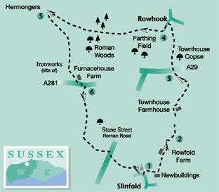
The north Sussex village of Slinfold is the starting point for this walk by Eddie Start, leading out onto the Low Weald, with Roman spectres, former ironworks and long views across the beautiful Wildwood.
1 - From the village street in Slinfold take the footpath that enters the churchyard left of the village hall. Follow the flagstone path, right of the church, to the far side of the churchyard. From a three-way path sign, turn right to the top, right corner. Pass through hedgerow into a field, continuing along the left edge towards Newbuildings. Keep to the left of the site and at a surfaced farm drive turn left. Climb the driveway for 300 yards and, just before the entrance to Rowfold Farm, leave the drive, to the right, and continue, beside hedgerow, above a sloping meadow.
The path soon begins a descent to a bridleway junction, above a stream that feeds into the River Arun. Turn right along the field edge to the left corner and go left over a bridge. Take a few paces right to a three- way bridleway sign. Note away to the left, beneath a sheltering oak, a brick-built defensive pillbox, which would have been a pleasant posting for the local Home Guard.
2 - From the signpost turn left, passing across the top of a meadow, on a field-centre path. Descend to enter, over a bridge, a small copse of very tall Small-Leaved Lime trees, a species common in the northern European Wildwood of earlier times. Leave the copse and continue across a wide meadow towards rail fencing around Townhouse Farmhouse. Keep the rail fence on the right, passing around it to the right and left, finally going right, to a driveway. Turn left along the drive, as it takes left and right turnings, climbing a short rise to the edge of the A29 road.
3 - Cross, with care, into Townhouse Copse and climb up through the mixed woodland for about one-third-of-a-mile.
At the top of the climb, at a three-way path junction, walk ahead to a field-edge stile and cross into a hilltop field. Take a half-left line across the field, on a trodden path, to the far left corner, pass through hedgerow and turn left on an enclosed path that soon skirts right and drops to a metalled driveway. Turn left up the lane, passing a derelict chapel building that is on the right. (Before turning left you could decide to go right, down the lane, to the Chequers Inn at Rowhook.) You may well experience the sense of spectral chariots and marching legions along this lane, because the Roman road of Stane Street ran through here in those far-off times.
4 - From the top of the lane, turn right on to a bridleway, passing right of the thatched Burnt Cottage into the woodland of Farthing Field. The track enters Roman Woods after a quarter-of- a-mile and passes over a crossing woodland drive in a similar distance. In a further quarter-of-a-mile the bridleway descends to a bridge and climbs steeply to a metal gate at a field edge, beside a three-way sign. Walk around the gatepost, taking a line on a trodden path up the wide field. The directions given here may appear perverse, given that the next stage of the route is a return down the fenceline a few yards away – all will be revealed shortly. Climb to the top of the field to a footpath sign, close to Hermongers. Take a complete turn-about to survey the canopy of tree-cover, disappearing south to the horizon. This scene is evocative of the Wildwood, or as our Saxon forebears designated it, The Weald; not as it was long ago but nonetheless a good impression of the extensive forest canopy that once existed.
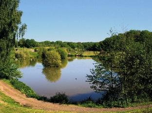
5 - From the signpost follow the right fenceline down the hill to a stile into the Wildwood. Follow a gully path for 100 yards to a crossing bridleway. Turn left for 75 yards to a three-way sign, turning right down a path and through hedgerow. In a clearing, with a large pond ahead, go quarter-left to cross a narrow footbridge that is only just above the water level. Turn right, keeping to the shoreline path for 350 yards and passing fishing platforms. The pond is a remnant of the Wealden iron industry, with the ironworks sited below the pond’s dam wall. On coming to the end of the pond the path veers left and then right. With the dam wall off to the right, pass across an open area and turn left beside a brick administration hut. Keep to the path above a second, lower pond that is on the right and passing a stone-built cottage, left, behind a hedge. On arriving at a gated, open area, turn left to a driveway, climbing to pass through ornamental gates.
Keep to the right and follow the drive to the roadside.
6 - Turn left along a verge and in 100 yards cross, with care, on to a surfaced bridleway leading to Dedisham Manor Farm. Pass farm cottages and head for the farm buildings. Do not take a left bridleway turn but continue on a footpath across the yard towards the buildings. Pass around a gate, with a cattle shed on the right and dairy on the left, continuing to a second gate and climbing away from the farm buildings on a surfaced footpath.
After 300 yards, the path continues beside trees for one-third-of-a-mile to the top of the hill, passing a crossing path. Turn left and follow a field-edge path for a quarter-of-a-mile to the edge of Stane Street. Cross with care and turn right for 50 yards to cross a stile in the left hedge. Follow the quarter-right path across two fields, passing through a hedge-opening to a third field and then climb beside a right tree-line to a lane, beside houses. Turn right along the lane, to the church in Slinfold village, close to the start of the walk.
* Distance/Time: Six miles, taking three hours.
* By Car: Roadside parking in Slinfold village, close to the church. Start point Grid Ref TQ118315
* By Public Transport: Bus stop in village. Bus details from www.traveline.info, phone 0871 200 2233.
* What’s underfoot: Easy Wealden walking with a few climbs and descents, but no seriously demanding challenges; possible with a baby backpack, not possible with a baby buggy.
* Thirsty Work: The Red Lyon in Slinfold and The Chequers at Rowhook.
* So you don’t get lost: OS Explorer maps 134, plus a compass for general direction.


Comments: Our rules
We want our comments to be a lively and valuable part of our community - a place where readers can debate and engage with the most important local issues. The ability to comment on our stories is a privilege, not a right, however, and that privilege may be withdrawn if it is abused or misused.
Please report any comments that break our rules.
Read the rules here