
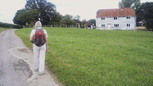
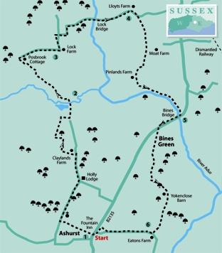
1 - From the roadside in Ashurst, cross a stile that is left of a wooden barn, opposite The Fountain Inn. Walk down the right hedgerow to a stile, continuing on an enclosed path. Cross plank bridges at the end of the footpath, into a quiet road.
Turn right, passing the flint-faced village church then, in a quarter of a mile, arrive at a road junction. Continue straight ahead, passing Holly Lodge and descending Ford Lane for 350 yards to Claylands Farm.
With a large green barn ahead, turn left between the barn and farmhouse, passing between buildings. In 200 yards turn right on a rising bridleway, going left in 150 yards. The path turns right again, passing across the top of a low hill and descending to a right turn after 300 yards. The path twists its way between the bushes, going left and crossing a bridge.
2 - On emerging from the hedgerow turn left through an opening, crossing a plank bridge and heading along a left field-edge. Follow a north-westerly direction – there is a stream on the right, beneath the hedgerow. Take care along this section, there are many ankle-twisting rabbit burrows across the path.
After about 350 yards, at the hedge corner, cross a stile and maintain direction in the next field. After about a quarter of a mile the distinctive blue clapperboard facade of Posbrook’s Cottage appears off to the right. Cross a field corner stile on the left and follow the path, going right for a few yards, beside a fence, to cross a second and third stile. Follow a trodden path across a reedy area with bulrushes to a wider access track. Turn right along the track, following the slow rise for a quarter of a mile, to a path junction at Lock Farm.
3 - Do not go ahead through gates into the farmyard, but turn left through a hedge opening and climb a right field-edge for 200 yards, to the end of hedgerow. Turn right, through an opening, walking on a surfaced driveway beside Lock Farm Cottages. Continue to the gated entrance of cottage number one, walk across a gravel drive and go left of a double garage. In a few paces turn left on a bridleway and in 100 yards turn right, beside a railing fence and hedgerow. In a further 100 yards the bridleway joins a farm track and continues eastward, soon crossing over the River Arun at Lock Bridge. Just south of the bridge is the site of the first (or last) lock gate on the former Arun Navigation. Continue along the track and on coming to Lloyts Farm locate a wooden five-bar gate on the right of the track, leading into a small garden.
4 - Go right around the gatepost and descend beside the right hedge, crossing a footbridge in the corner.
In the next field the ongoing path crosses the field but when this walk was surveyed the path had not been reinstated and there were waist-high crops. Go right for about 50 yards and, just before a hedge opening, turn left along the hedgerow to a field corner opening in 150 yards. Go right through the opening and walk across the next field, with Moat Farm away to the left. Cross a stile, beside a metal gate, and keep direction over the next field for 300 yards. At the far side of the field, pass through hedgerow on a plank bridge and turn right for 50 yards, crossing a stile beside a gate at Pinlands Farm. Walk along the driveway for a few yards and, after a small flint barn on the left, go half-left across a grassed area, making for an enclosed footpath, left of an outbuilding. On coming to a stile in the right hedgerow, cross and turn left descending to a left turn over another stile into a small field. At the next stile go half-right to a riverbank footpath sign. Turn left along the bank-top path, with the River Adur on the right, heading for Bines Bridge, a quarter of a mile away.
5 - Turn right over the bridge and follow the roadside, with care, for 150 yards to wider verges at Bines Green. Walk along the verge a short way, then locate a path sign on the left, cross the road and follow the faintly trodden path, close to the left hedgeline, to the southern end.
Enter a hedgerow tunnel and in a few paces go half-left crossing a plank bridge and stile, into a meadow. Walk ahead to cross a stile into a small garden beside the wooden Withyfield Cottage. Pass into a lane and turn left, taking right and left turns to the farm buildings at Yokenclose Barn. Walk ahead through double gates, veer right between buildings to a gate at the far side of the yard.
Continue over a narrow meadow and, at the far side, cross into a sloping field, heading half-right for a metal kissing gate. Climb, passing mature oak trees, to the right of a four-way path sign at the midway point.
6 - At the top of the field, beside Eatons Farm, cross a stile and take a half-right line across a lawn, with an outbuilding on the right, to a corner bridle gate.
Turn right along a drive for one third of a mile and just after a low barn, on the right, turn right through an opening, resuming direction to the roadside. Turn left, passing the village hall at Ashurst to arrive at The Fountain Inn. The inn was one of the stopping-off points in Hilaire Belloc’s tale of The Four Men, a traverse across the rural landscape of Sussex in 1902 by Myself, Grizzlebeard, The Sailor and The Poet, each character being an aspect of Belloc’s own nature. So, settle into a settle, beside a log fire, and muse on rural Sussex.
* Distance/Time: Six miles, taking two and three quarter hours.
* By Car: Ashurst is on the B2135 road, about two and a half miles north of the A283 turning, north of Steyning. Some local, on-street parking. Get permission to use the pub car park. Start point grid ref TQ180161, opposite the The Fountain Inn.
* By Public Transport: Travel details from www.traveline.info, phone 0871 2002233. Bus to Ashurst, close to starting point.
* What’s underfoot: Level Wealden walking and no steep climbs, but plenty of stiles. Possible with a baby backpack, not possible with a baby buggy.
* Thirsty Work: The Fountain Inn at Ashurst.
* So you don’t get lost: OS Explorer map 122, plus a compass for general direction.


Comments: Our rules
We want our comments to be a lively and valuable part of our community - a place where readers can debate and engage with the most important local issues. The ability to comment on our stories is a privilege, not a right, however, and that privilege may be withdrawn if it is abused or misused.
Please report any comments that break our rules.
Read the rules here