
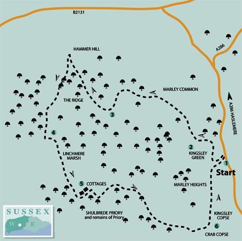
1. From beside the cottages, west of the Midhurst to Haslemere road (A286) at Kingsley Green, follow the unfenced minor road for 200 yards to a footpath leading off to the right, just before the road climbs through woodland.
Turn right (yellow arrow) on to the footpath and walk for 300 yards, taking a signed left turning (yellow arrow) immediately after Rose Cottage. The path climbs up an increasing incline through woodland, bearing left as it clears the top of gardens.
Keep to the main track through rhododendron and holly bushes to a surfaced driveway, after a heavy-breathing ascent of 250 yards. Cross over the drive to locate a continuing footpath that in 100 yards arrives at a minor road.
2. Turn right along the road and, after about 100 yards, take a signed woodland footpath branching right. In 250 yards the path crosses a surfaced drive, passing through a bridle gate and continuing ahead in more sparse woodland. Keep to the path for 350 yards across Marley Common to a five-way junction of paths and bridleways.
Take the bridleway option to the half-left on to heathland, following the path to a marker post and bearing left at a fork, descending back into woodland. From a signpost, turn left towards double gates at a
junction of minor roads.
Head for the signed, surfaced bridleway going quarter-right and coming to an information board for the Linchmere Society, a local conservation body, in
a short distance.
The bridleway sweeps left, descending and then climbing out from a hollow. Ignore footpath turnings off to the right as you ascend the rise. At the top of the climb walk ahead on the surfaced drive, ignoring a left-turning bridleway.
At a minor junction, beside a house on the right called Harboury, continue into woodland on an unsurfaced bridleway.
3. In 100 yards, at a bridleway junction, take the right turning. Follow the main bridleway for half a mile, taking none of the branching diversions. Finally cross a wider track and walk ahead beneath a holly tunnel to arrive, in a few yards, at the rear of dwellings close to Hammer Hill – there is a marker post beside a
chestnut paling fence.
Turn left (yellow arrow) beside the fence and in a few yards bear left again, cross over the track and follow the southbound footpath.
Keep to the path for 250 yards. At a marker post, bear left and climb a short ramp, taking the left fork beneath holly bushes. Continue for about 150 yards to a signpost at a junction of tracks and walk ahead for 25 yards to
a fork in the path.
Take the right branch on a descending path, coming to the edge of the woodland called The Ridge, with paddocks through hedgerow on the right. Climb for 250 yards to a crossing bridleway, with a house behind bushes to the right.
Follow the opposite footpath, passing by a traditional sandstone-built barn that has a corrugated sheet steel roof. Keep to the path, passing through a metal kissing gate and descending a gully path among bushes.
4. Take a left turning at the bottom of the incline – there is a minor road off to the right. In 150 yards the path bears right and begins a descent, passing a delightfully landscaped garden, seen through hedgerow on the right.
At the bottom of the slope, take the right fork in the path, ignoring left branches, and in a further 50 yards, at a three-way sign, take the right fork on the descending gully path. When beside an outbuilding, next to a house, ignore a right turn and continue ahead down a drive. At a right turning, take the faintly trodden path, branching left across ground that confirms why this area is known as Linchmere Marsh.
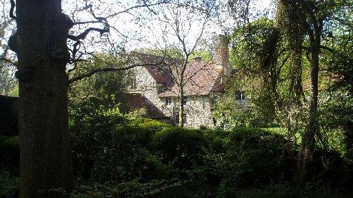
At the roadside, turn left for a quarter of a mile to arrive beside cottages and a poultry farm, close to Shulbrede Priory.
Through the trees, to the left, are the remains of the priory that has history. In the early morning of Monday, October 4, 1535, Commissioner Richard Layton arrived with his heavies to evict the Augustinian Black Canon monks. Stories had reached London alleging, among other sins, that the monks were guilty of lewd behaviour with the nuns of Easebourne. It was too much for a god-fearing society.
Thomas Cromwell’s men turfed the monks out and began counting the booty. Enough of the building remained to be gifted to one of the King Harry’s chums as a country pad. Happy days. What happened to the nuns? That’s another story.
5. Turn left on a signed footpath (yellow arrow) beside the cottages and in 200 yards turn right. In a further 200 yards, at a three-way junction, turn left and climb for 300 yards, passing a young plantation and a deer stalker’s platform, on the left, to a fork in the footpath.
Branch right up a rutted path in Greenhill Wood, passing recently cleared coppice. Turn left, up a short climb, and then turn right, through the extensive woodland. Ignore a right turning after a quarter of a mile. The path continues for a further half a mile on a wide, leftward sweep, as it traverses the hillside above Crab Copse.
6. On coming to a path junction, gate and stile (ignore the descending right turning) walk ahead for about 20 yards, joining a restricted byway coming from the right. Continue for a further 100 yards, diverting right on to a footpath that passes through Kingsley Copse, beneath overhead power cables.
In a quarter of a mile the footpath comes to a driveway, serving houses, and climbs through Marley Heights to a minor road.
Walk ahead, northward, along the road, descending to the road junction from the beginning of this expedition. Turn right back towards the houses of Kingsley Green and our starting point.
- Distance/Time: Six miles, taking three hours
- By Car: Roadside parking at Kingsley Green, turn west off the A286 road into Marley Lane, one and a half miles north of Fernhurst. Start point Grid Ref: SU895306
- By Public Transport: Midhurst to Haselmere bus hourly, not Sundays. Bus stop at Kiln Meadow, walk back to start of walk (five mins) and go west into Marley Lane. Travel details from www.traveline.info, phone 0871 2002233
- What’s underfoot: Mainly woodland walking, with a steep climb at the start. Very pleasant and isolated countryside with some heathland. Not recommended with a baby backpack; not possible with a baby buggy
- Thirsty Work: Nearest refreshment at The Red Lion, The Green, Fernhurst, one and a half miles south on the A286
- So you don’t get lost: OS Explorer map 133, plus a compass for general direction
Click here for a full-sized map of the Kingsley Green circular walk


Comments: Our rules
We want our comments to be a lively and valuable part of our community - a place where readers can debate and engage with the most important local issues. The ability to comment on our stories is a privilege, not a right, however, and that privilege may be withdrawn if it is abused or misused.
Please report any comments that break our rules.
Read the rules here