
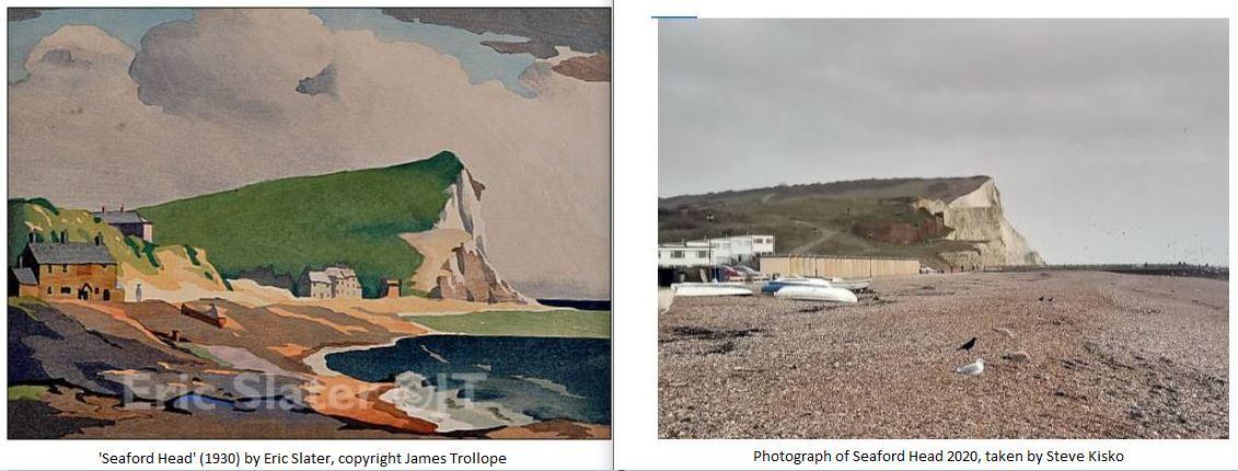
Nearly 100 years ago local Seaford resident Eric Slater developed an international reputation as a colour woodcut artist before dying relatively unknown in 1963. To learn more, Steve Kisko walks across Seaford Head following part of the ‘Slater Trail’, a route created to re-discover some of the coastal scenes that were the subject of his artwork.
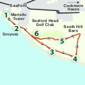
1. Start at Seaford Martello Tower on Esplanade, along Seaford seafront. Make your way around to the beach side of the tower and as you look out to sea turn left to view the cliffs of Seaford Head. This scene is similar to Slater’s woodcut of 1930 called Seaford Head. Begin to walk towards Seaford Head along the promenade, passing beach huts on your left and the pebbled beach itself on your right. This is also part of the Vanguard Way (VW) which you will follow until you later turn left inland at point 4.
2. In 450 yards reach the base of the cliffs and a place called Splash Point which formed the basis of Slater’s ‘Rough Sea’ artwork of 1929. Leave the promenade away from the beach and begin to head up the side of the cliffs ahead taking the left-hand path that bends up around to the left to a viewing platform. Keep away from the cliff edge which is mostly fenced off with low ropes. Begin to follow a fence line on your left which leads out on to a flatter area (Hawks Brow) with Seaford Head golf course to your left. A sensible route is to follow the line where the thicker rough grass on your left meets the shorter grass on your right. Gradually you begin to climb up the side of Seaford Head to the top. Try to keep off the golf course but away from the cliffs. Pass the teeing off point for the 18th hole on your way up, soon followed by a putting green. Continue walking along the coast with sea views on your right.
3. In about 400 yards you come level with a weather station building about 200 yards away to the left. Continue ahead as you pass a sign welcoming you to Seaford Head Nature Reserve. In a further 100 yards you will pass near the green for the 15th hole over to your left. Soon after there is an interesting sign about the spot being called Buckle Church. Leave the golf course behind and follow a fence on your left with fields beyond.
4. In about 400 yards as you level up with a barn (South Hill Barn) away to the left, and before the path begins to start going downhill, turn left away from the cliff, over a stile and into the field, leaving the VW here. Now follow a permissive footpath directly ahead aiming for the barn about 600 yards in the distance. Exit the field over a stile about 20 yards to the left of the barn. On the side of the barn there is a handy map and sign about the Slater Trail this walk is based on. Otherwise, turn left over grass before the car park and follow a footpath on the straight concrete road beyond a vehicle barrier.
5. In 500 yards re-enter the area of the golf course with the 14th hole on your right. Continue ahead through a section bounded by gorse. Ignore a path to your left that goes to a telephone mast. As the concrete runs out continue ahead keeping close to the bushes on your left and off the golf course on your right. In 150 yards ignore 2 paths to the left and continue following the bushes on your left. Pass the 13th tee on your right and continue as the path becomes bordered by hedges. At a T-junction ignore a gravel path leading downhill to the right but veer left up a bank on to the golf course again; then keep close to the bushes on your right.
6. In about 100 yards, well before the cliff edge, turn right to re-join the cliff top path you were on earlier. Head downhill past the 18th tee on your right taking care on the slippery grass. Re-trace your steps back down to Splash Point, along the promenade and return to the Martello Tower ahead.
Distance/time: 3 miles taking 1 and a half hours.
Public transport: Compass Travel operate bus service number 119 which stops at the Martello Tower on Saturdays.
Car: The start is easily accessible by car via Seaford seafront along the Esplanade road where on-street parking is available.
Underfoot: Be prepared for a steady climb uphill after walking along the flat promenade. Always stay well away from the cliff top and never go beyond the roped-off areas. Avoid very windy days. Wear strong shoes and take care on descending Seaford Head allowing plenty of time. Most of the walk is on grass with some stretches of concrete.
Thirsty work: There is a little ice-cream hut with outside seating selling drinks and snacks next to the Martello Tower. Public toilets are adjacent.
NOTE: Based on ‘The Slater Trail’ created by Slater expert James Trollope. Image of ‘Seaford Head’ (left) is copyright © James Trollope who has given kind permission for its reproduction and this walk idea. See www.ericslater.co.uk for more details.
Maps: OS Explorer 123; OL25.


Comments: Our rules
We want our comments to be a lively and valuable part of our community - a place where readers can debate and engage with the most important local issues. The ability to comment on our stories is a privilege, not a right, however, and that privilege may be withdrawn if it is abused or misused.
Please report any comments that break our rules.
Read the rules hereLast Updated:
Report this comment Cancel